In this relatively short blog post, we’ll use PHP/MySQL and Google Maps Javascript API to display locations from a MySQL database on a map.
We’ll make a simple “City guide to Zagreb”, meaning we’ll select interesting locations from the database, display them on a map, show some info about them and show directions from the user’s current position to a location of his/her choice.
What you’ll need
- PHP/MySQL Development Environment
- Some understanding of JavaScript
- Some free time
As you can see it’s really easy to get started. So, let’s do it!
The Database
First, let’s create a table for our data:
CREATE TABLE `locations` (
`id` INT(10) NOT NULL AUTO_INCREMENT,
`name` VARCHAR(150) NOT NULL,
`address` VARCHAR(255) NOT NULL,
`lat` FLOAT(10,6) NOT NULL,
`lon` FLOAT(10,6) NOT NULL,
`description` TEXT NOT NULL,
PRIMARY KEY (`id`)
)
COLLATE='utf8_general_ci'
ENGINE=InnoDB
Then, use phpMyAdmin or your favourite MySQL client to enter some data about locations. Or, if you don’t feel like it, here’s my data:
INSERT INTO `locations` (`id`, `name`, `address`, `lat`, `lon`, `description`) VALUES (1, 'Archaeological Museum', 'Nikola Šubić Zrinski Square 19, 10000, Zagreb, Croatia', 45.823704, 15.990757, 'The Archaeological Museum in Zagreb, Croatia is an archaeological museum with over 450,000 varied artifacts and monuments, gathered from various sources.');
INSERT INTO `locations` (`id`, `name`, `address`, `lat`, `lon`, `description`) VALUES (2, 'Modern Gallery', 'Andrije Hebranga 1, 10000, Zagreb, Croatia', 45.809280, 15.977570, 'Modern Gallery is a museum in Zagreb, Croatia that holds the most important and comprehensive collection of paintings, sculptures and drawings by 19th and 20th century Croatian artists.');
INSERT INTO `locations` (`id`, `name`, `address`, `lat`, `lon`, `description`) VALUES (3, 'Technical Museum', 'Savska cesta 18, 10000, Zagreb, Croatia', 45.803555, 15.965023, 'The museum was founded in 1954 and it maintains the oldest preserved steam engine in the area, dating from the mid-19th century, which is still operational.');
INSERT INTO `locations` (`id`, `name`, `address`, `lat`, `lon`, `description`) VALUES (4, 'St. Mark\'s Church', 'Saint Mark\'s Square 5, 10000, Zagreb, Croatia', 45.816677, 15.973806, 'The Romanesque window found in its south facade is the best evidence that the church must have been built as early as the 13th century as is also the semicircular groundplan of St. Mary\'s chapel');
INSERT INTO `locations` (`id`, `name`, `address`, `lat`, `lon`, `description`) VALUES (5, 'Zagreb Cathedral', 'Kaptol 31, 10000, Zagreb, Croatia', 45.816723, 15.978199, 'Zagreb Cathedral on Kaptol is the most famous building in Zagreb, and the tallest building in Croatia.');
INSERT INTO `locations` (`id`, `name`, `address`, `lat`, `lon`, `description`) VALUES (6, 'The Grounded Sun', 'Bogovićeva, 10000, Zagreb, Croatia', 45.812180, 15.975432, 'Nine Views is an ambiental installation in Zagreb, Croatia which, together with the sculpture The Grounded Sun, makes up a consistent model of solar system.');
INSERT INTO `locations` (`id`, `name`, `address`, `lat`, `lon`, `description`) VALUES (7, 'Croatian National Theatre', 'Marshal Tito Square 15, 10000, Zagreb, Croatia', 45.810184, 15.970123, 'The Croatian National Theatre in Zagreb is a theatre located in Zagreb, owned and operated by the Ministry of Culture');
INSERT INTO `locations` (`id`, `name`, `address`, `lat`, `lon`, `description`) VALUES (8, 'Museum of Contemporary Art', 'Dubrovnik Avenue 17, 10000, Zagreb, Croatia', 45.777695, 15.977888, 'The museum traces its origins from the City Gallery of Contemporary Art which was established in 1954.');
INSERT INTO `locations` (`id`, `name`, `address`, `lat`, `lon`, `description`) VALUES (9, 'Maksimir Park', 'Maksimir Park, 10000, Zagreb, Croatia', 45.829090, 16.019424, 'Maksimir Park features artificial lakes, an Echo Pavilion and the 19th century Bellevue Pavilion.');
INSERT INTO `locations` (`id`, `name`, `address`, `lat`, `lon`, `description`) VALUES (10, 'Mimara Museum', 'Trg Franklina Delanoa Roosevelta 5, 10000, Zagreb, Croatia', 0.000000, 0.000000, 'It is located in a late 19th century neo-Renaissance palace. The holdings comprise 3,750 works of art of various techniques and materials, and different cultures and civilizations.');
INSERT INTO `locations` (`id`, `name`, `address`, `lat`, `lon`, `description`) VALUES (11, 'Strossmayer Gallery of Old Masters', 'Nikola Šubić Zrinski Square 11, 10000, Zagreb, Croatia', 45.823704, 15.990757, 'The Strossmayer Gallery holding includes around 4,000 works, of which some 250 are on display, with the remainder in storage, or on display at other museums or gallery institutions in Croatia.');
INSERT INTO `locations` (`id`, `name`, `address`, `lat`, `lon`, `description`) VALUES (12, 'Vatroslav Lisinski Concert Hall', 'Stjepan Radić Square 4, 10000, Zagreb, Croatia', 0.000000, 0.000000, 'Vatroslav Lisinski Concert Hall is a large concert hall and convention center in Zagreb, Croatia. It is named after Vatroslav Lisinski, a 19th-century Croatian composer.');
INSERT INTO `locations` (`id`, `name`, `address`, `lat`, `lon`, `description`) VALUES (13, 'Lotrščak Tower', 'Dverce, 10000, Zagreb, Croatia', 45.814510, 15.973316, 'The tower, which dates to the 13th century, was built to guard the southern gate of the Gradec town wall.');
INSERT INTO `locations` (`id`, `name`, `address`, `lat`, `lon`, `description`) VALUES (14, 'Jarun Lake', 'Jarun Lake, 10000, Zagreb, Croatia', 45.783333, 15.916667, 'Jarun Lake is a popular getaway for residents any time of year but especially in the summer when the clear waters are ideal for swimming.');
INSERT INTO `locations` (`id`, `name`, `address`, `lat`, `lon`, `description`) VALUES (15, 'Botanical Garden', 'Trg Marka Marulica 9a, Zagreb, Croatia (Botanical Gardens)', 0.000000, 0.000000, 'In addition to 10,000 species of plant, including 1800 tropical flora specimens, the landscaping has created restful corners and paths that seem a world away from bustling Zagreb.');
Note that some locations have empty coordinates, and have only their addresses entered. This is deliberate so we can write code to handle those situations as well. If we encounter a location without coordinates entered into the database, we’ll try to Geocode its address into coordinates.
Create a Simple map
First, let’s create a simple map, just to verify how things should work on a map.
Create a new file named index.html which will display our results and do other cool stuff with maps. For now, we’ll only create a basic map:
<!DOCTYPE html>

<html lang="en">
<head>
<meta charset="utf-8" />
<title>Google Maps Example</title>
<style type="text/css">
body { font: normal 14px Verdana; }
h1 { font-size: 24px; }
h2 { font-size: 18px; }
#sidebar { float: right; width: 30%; }
#main { padding-right: 15px; }
.infoWindow { width: 220px; }
</style>
<script type="text/javascript" src="http://maps.google.com/maps/api/js?sensor=false"></script>
<script type="text/javascript">
//<![CDATA[

var map;

// Ban Jelačić Square - Center of Zagreb, Croatia
var center = new google.maps.LatLng(45.812897, 15.97706);

function init() {

var mapOptions = {
zoom: 13,
center: center,
mapTypeId: google.maps.MapTypeId.ROADMAP
}

map = new google.maps.Map(document.getElementById("map_canvas"), mapOptions);

var marker = new google.maps.Marker({
map: map,
position: center,
});
}
//]]>
</script>
</head>
<body onload="init();">

<h1>Places to check out in Zagreb</h1>

<section id="sidebar">
<div id="directions_panel"></div>
</section>

<section id="main">
<div id="map_canvas" style="width: 70%; height: 500px;"></div>
</section>

</body>
</html>
In body, we created a div to hold the map. Because the map takes dimensions from the container div it needs to have dimensions. We use onload function to run the init function when our page loads. In the init function, we create a new map that uses the options we specified. Then we create a map marker and display it.
Save the file and run it in the browser to see what we got.
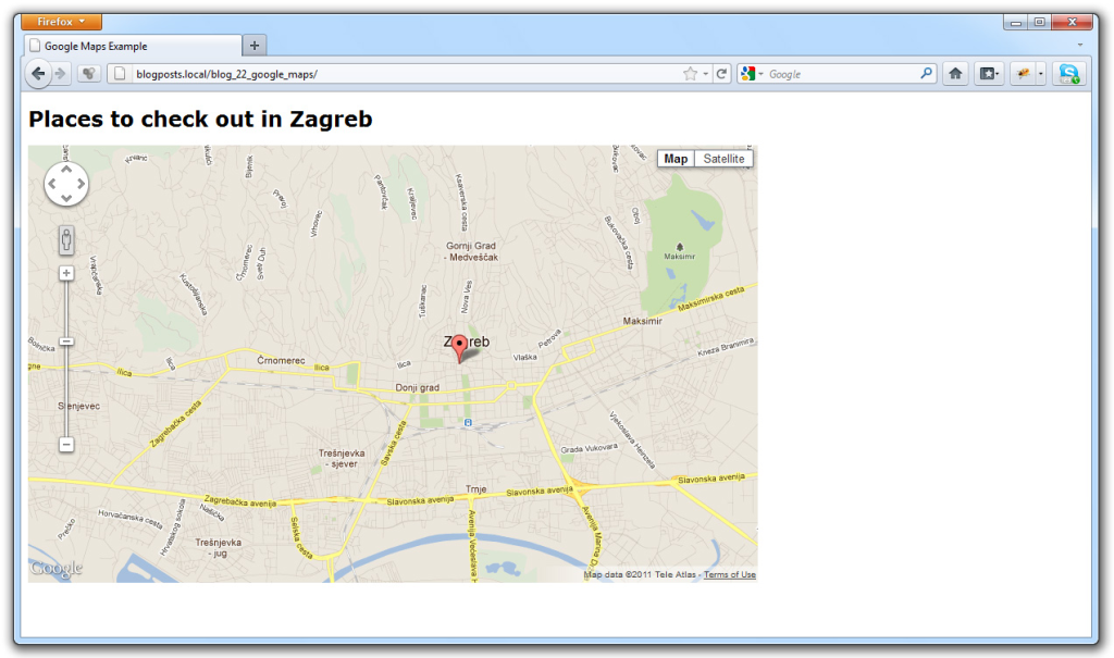
OK, we’ve scratched the surface, and now we need some data to display on the map.
Getting data from the database
Let’s fetch data from the database to display on our map. We’ll use Ajax request to get location data. From PHP script we’ll echo data in JSON format and then process it via JavaScript. I know, it may sound confusing for beginners, but it’s really not. Just follow along, and things will be more clear.
First, let’s create a config.php file. Inside we’ll configure some variables needed for database access:
<?php

$server     = 'localhost';
$username   = 'root';
$password   = 'YOUR_PASSWORD';
$database   = 'YOUR_DATABASE';

$dsn        = "mysql:host=$server;dbname=$database";
Create a file that will return the actual data. I named it get_locations.php. This file should contain the following code:
<?php

require 'config.php';

try {

$db = new PDO($dsn, $username, $password);
$db->setAttribute( PDO::ATTR_ERRMODE, PDO::ERRMODE_EXCEPTION );

$sth = $db->query("SELECT * FROM locations");
$locations = $sth->fetchAll();

echo json_encode( $locations );

} catch (Exception $e) {
echo $e->getMessage();
}
You can run the get_locations.php file to verify that it correctly returns our locations as a JSON string:

We’re done with the PHP side of things. Cool, right?
Displaying locations on the map
The first thing we’ll need to do is a way to make an Ajax request and a way to process the results that request returns to us. As we already know, our PHP file will return JSON to us.
We won’t use an external library, so inside a JavaScript block of our index.html file create a new function for making Ajax requests.
function makeRequest(url, callback) {
var request;
if (window.XMLHttpRequest) {
request = new XMLHttpRequest(); // IE7+, Firefox, Chrome, Opera, Safari
} else {
request = new ActiveXObject("Microsoft.XMLHTTP"); // IE6, IE5
}
request.onreadystatechange = function() {
if (request.readyState == 4 && request.status == 200) {
callback(request);
}
}
request.open("GET", url, true);
request.send();
}
This is a pretty standard function, everyone’s using some variation of it, so there’s no need to get into details. All you need to know is that we’ll provide two parameters for this function: url where to make an Ajax request and a callback function which will be called with data sent back as a parameter.
So, let’s use our newly added function inside our init function. Let’s add the call after we create a map. Also, let’s add a Geocoder and Infowindow objects because we’ll need them here.
var map;

// Ban Jelačić Square - City Center
var center = new google.maps.LatLng(45.812897, 15.97706);

var geocoder = new google.maps.Geocoder();
var infowindow = new google.maps.InfoWindow();

function init() {

var mapOptions = {
zoom: 13,
center: center,
mapTypeId: google.maps.MapTypeId.ROADMAP
}

map = new google.maps.Map(document.getElementById("map_canvas"), mapOptions);

makeRequest('get_locations.php', function(data) {

var data = JSON.parse(data.responseText);

for (var i = 0; i < data.length; i++) {
displayLocation(data[i]);
}
});
}
So, we added a makeRequest call. The callback function first uses JSON.parse to convert JSON string into an array of objects. Each object is basically one row from a database and it represents a location, so inside a loop we call a displayLocation function with an object as a parameter.
In the displayLocation function we’ll display that location on the map:
function displayLocation(location) {

var content =   '<div class="infoWindow"><strong>'  + location.name + '</strong>'
+ '<br/>'     + location.address
+ '<br/>'     + location.description + '</div>';

if (parseInt(location.lat) == 0) {
geocoder.geocode( { 'address': location.address }, function(results, status) {
if (status == google.maps.GeocoderStatus.OK) {

var marker = new google.maps.Marker({
map: map,
position: results[0].geometry.location,
title: location.name
});

google.maps.event.addListener(marker, 'click', function() {
infowindow.setContent(content);
infowindow.open(map,marker);
});
}
});
} else {
var position = new google.maps.LatLng(parseFloat(location.lat), parseFloat(location.lon));
var marker = new google.maps.Marker({
map: map,
position: position,
title: location.name
});

google.maps.event.addListener(marker, 'click', function() {
infowindow.setContent(content);
infowindow.open(map,marker);
});
}
}
As you can see the function is basically simple. First, we create HTML content that’ll go inside a marker, so we have it ready. Then we check if we have latitude and longitude for that location and if we don’t we’ll use Geocoding to get the latitude and longitude from a location’s address. If the geocoding process succeeds we use that data to create a marker.
NOTE: We can’t use geocoding service for a lot of results, because of the limitations. That is precisely the reason we need to have coordinates stored in the database. For more information please take a look at Geocoding Strategies on Google maps api documentation.
If we have latitude and longitude we use that to create a marker. When we create a marker we’ll add an event listener to the marker -> When we click on the marker open an InfoWindow containing the information about the location.
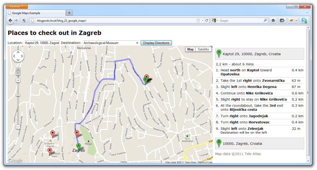
Save the file and open index.html via the web server to see what we got.

We’ve successfully added all the locations to the map. Now, let’s add the directions to each of the locations.
Displaying Directions to locations
Inside the body create a form so that the user can enter his/her position and choose a location. Also, add a panel in which to display directions.
<body onload="init();">

<h1>Places to check out in Zagreb</h1>

<form id="services">
Location: <input type="text" id="start" />
Destination: <select id="destination" onchange="calculateRoute();"></select>
<input type="button" value="Display Directions" onclick="calculateRoute();" />
</form>

<section id="sidebar">
<div id="directions_panel"></div>
</section>

<section id="main">
<div id="map_canvas" style="width: 70%; height: 500px;"></div>
</section>

</body>
If you refresh the page now, you’ll see that the form is added, but the destinations select box is empty. So, we need to fill that as well. In addition, we’ll try to automatically detect the user’s location.

First, we’ll need to create two new objects before the init function – DirectionsService and DirectionsRenderer.
var directionsService = new google.maps.DirectionsService();
var directionsDisplay = new google.maps.DirectionsRenderer();
We need to configure the directionsDisplay object. We can do it inside our init function. Also, let’s add autodetection of the user’s location to our init function.
var map;

// Ban Jelačić Square - City Center
var center = new google.maps.LatLng(45.812897, 15.97706);

var geocoder = new google.maps.Geocoder();
var infowindow = new google.maps.InfoWindow();

var directionsService = new google.maps.DirectionsService();
var directionsDisplay = new google.maps.DirectionsRenderer();

function init() {

var mapOptions = {
zoom: 13,
center: center,
mapTypeId: google.maps.MapTypeId.ROADMAP
}

map = new google.maps.Map(document.getElementById("map_canvas"), mapOptions);

directionsDisplay.setMap(map);
directionsDisplay.setPanel(document.getElementById('directions_panel'));

// Detect user location
if(navigator.geolocation) {
navigator.geolocation.getCurrentPosition(function(position) {

var userLocation = new google.maps.LatLng(position.coords.latitude,position.coords.longitude);

geocoder.geocode( { 'latLng': userLocation }, function(results, status) {
if (status == google.maps.GeocoderStatus.OK) {
document.getElementById('start').value = results[0].formatted_address
}
});

}, function() {
alert('Geolocation is supported, but it failed');
});
}

makeRequest('get_locations.php', function(data) {

var data = JSON.parse(data.responseText);
var selectBox = document.getElementById('destination');

for (var i = 0; i < data.length; i++) {
displayLocation(data[i]);
addOption(selectBox, data[i]['name'], data[i]['address']);
}
});
}

function addOption(selectBox, text, value) {
var option = document.createElement("OPTION");
option.text = text;
option.value = value;
selectBox.options.add(option);
}
We use the W3C Geolocation. If the geolocation succeeds we use Geocoding to get the user’s address. If this succeeds we enter that location into the location text box.
We also added the addOption function which adds options to a select box. So, inside our for loop we call the addOption function with selectbox, name and address parameters. The first parameter indicates which select box to fill.
Next, add a calculateRoute function inside our JavaScript:
function calculateRoute() {

var start = document.getElementById('start').value;
var destination = document.getElementById('destination').value;

if (start == '') {
start = center;
}

var request = {
origin: start,
destination: destination,
travelMode: google.maps.DirectionsTravelMode.DRIVING
};
directionsService.route(request, function(response, status) {
if (status == google.maps.DirectionsStatus.OK) {
directionsDisplay.setDirections(response);
}
});
}
This function is pretty simple. It uses text from the input field as an origin address and a selected location as a destination. If the field is empty, we’ll use city centre as a starting point.
We then use route method to issue a request to the Directions service. If the status is OK, we display directions.
If you refresh the page now and click the button or change a select box, the directions will be displayed, which means we’re done with the map.
Additional: Obtaining location coordinates
You might say, getting the coordinates manually and then entering them into the database is not very fun. And as we saw earlier, Google Geocoding service can be used to geocode addresses into latitudes and longitudes. After that, we can use PHP/MySQL to update those coordinates for locations.
If you decide to go that way, here’s a piece of JavaScript code you can use to send an Ajax request to update latitude and longitude (insert it into displayLocation function – if geocoding succeeds):
// Save geocoding result to the Database
// Please note that this is NOT Production-Ready Code !!
var url =   'set_coords.php?id=' + location.id
+ '&lat=' + results[0].geometry.location.lat()
+ '&lon=' + results[0].geometry.location.lng();

makeRequest(url, function(data) {
if (data.responseText == 'OK') {
// Success
}
});
The PHP file (set_coords.php) to update latitude and longitude would go something like this:
<?php

require 'config.php';

try {

$db = new PDO($dsn, $username, $password);
$db->setAttribute( PDO::ATTR_ERRMODE, PDO::ERRMODE_EXCEPTION );

$sth = $db->prepare("UPDATE locations SET lat = ?, lon = ? WHERE id = ?");
if ($sth->execute(array($_GET['lat'], $_GET['lon'], $_GET['id'])))
echo "OK";

} catch (Exception $e) {
echo $e->getMessage();
}
That’s basically it. Let’s repeat the entire JavaScript again so that you have everything in one place:
var map;
// Ban Jelačić Square - City Center
var center = new google.maps.LatLng(45.812897, 15.97706);
var geocoder = new google.maps.Geocoder();
var infowindow = new google.maps.InfoWindow();
var directionsService = new google.maps.DirectionsService();
var directionsDisplay = new google.maps.DirectionsRenderer();
function init() {
var mapOptions = {
zoom: 13,
center: center,
mapTypeId: google.maps.MapTypeId.ROADMAP
}
map = new google.maps.Map(document.getElementById("map_canvas"), mapOptions);
directionsDisplay.setMap(map);
directionsDisplay.setPanel(document.getElementById('directions_panel'));
// Detect user location
if(navigator.geolocation) {
navigator.geolocation.getCurrentPosition(function(position) {
var userLocation = new google.maps.LatLng(position.coords.latitude,position.coords.longitude);
geocoder.geocode( { 'latLng': userLocation }, function(results, status) {
if (status == google.maps.GeocoderStatus.OK) {
document.getElementById('start').value = results[0].formatted_address;
}
});
}, function() {
alert('Geolocation is supported, but it failed');
});
}
makeRequest('get_locations.php', function(data) {
var data = JSON.parse(data.responseText);
var selectBox = document.getElementById('destination');
for (var i = 0; i < data.length; i++) {
displayLocation(data[i]);
addOption(selectBox, data[i]['name'], data[i]['address']);
}
});
}
function displayLocation(location) {
var content = '<div class="infoWindow"><strong>' + location.name + '</strong>'
+ '<br/>' + location.address
+ '<br/>' + location.description + '</div>';
if (parseInt(location.lat) == 0) {
geocoder.geocode( { 'address': location.address }, function(results, status) {
if (status == google.maps.GeocoderStatus.OK) {
var marker = new google.maps.Marker({
map: map,
position: results[0].geometry.location,
title: location.name
});
google.maps.event.addListener(marker, 'click', function() {
infowindow.setContent(content);
infowindow.open(map,marker);
});
/* Save geocoding result to the Database
var url = 'set_coords.php?id=' + location.id
+ '&lat=' + results[0].geometry.location.lat()
+ '&lon=' + results[0].geometry.location.lng();
makeRequest(url, function(data) {
if (data.responseText == 'OK') {
// Success
}
});*/
}
});
} else {
var position = new google.maps.LatLng(parseFloat(location.lat), parseFloat(location.lon));
var marker = new google.maps.Marker({
map: map,
position: position,
title: location.name
});
google.maps.event.addListener(marker, 'click', function() {
infowindow.setContent(content);
infowindow.open(map,marker);
});
}
}
function addOption(selectBox, text, value) {
var option = document.createElement("OPTION");
option.text = text;
option.value = value;
selectBox.options.add(option);
}
function calculateRoute() {
var start = document.getElementById('start').value;
var destination = document.getElementById('destination').value;
if (start == '') {
start = center;
}
var request = {
origin: start,
destination: destination,
travelMode: google.maps.DirectionsTravelMode.DRIVING
};
directionsService.route(request, function(response, status) {
if (status == google.maps.DirectionsStatus.OK) {
directionsDisplay.setDirections(response);
}
});
}
function makeRequest(url, callback) {
var request;
if (window.XMLHttpRequest) {
request = new XMLHttpRequest(); // IE7+, Firefox, Chrome, Opera, Safari
} else {
request = new ActiveXObject("Microsoft.XMLHTTP"); // IE6, IE5
}
request.onreadystatechange = function() {
if (request.readyState == 4 && request.status == 200) {
callback(request);
}
}
request.open("GET", url, true);
request.send();
}
So, there you have it. A simple map with locations displayed from the database, directions to those locations and info windows displaying info about locations. We even have simple means for getting coordinates and storing them in the database.
NOTE: This is by no means a complete production-ready solution and it basically serves to show how easy it’s to start using Google Maps API. Also, note that the proposed solution to the problem of not having coordinates for some locations is not optimal. The best solution would be to use a Google Maps Geocoding Service with PHP to update coordinates in the database, so we have them ready. To do that, I suggest you take a look at the Geocoding Addresses with PHP/MySQL article.
I hope you found something useful in this tutorial. Thanks for visiting this site and until next time I wish you smooth work days without stress and nervousness.